|
What is GPS? Global Positioning System (GPS) is a satellite-based navigation
system made up of a network of 24 satellites placed into orbit by the U.S.
Department of Defense. GPS was intended for the use of the military only but
in the 1980s, the government made it available for civilian use. GPS works
in any weather conditions, anywhere in the world, 24 hours a day and it's
free of charge.
The GPS satellites circle the earth twice a day in very precise orbits and
transmit information signals to earth. The GPS receivers use the information
signals to triangulate the user's latitude/longitude position. Then if
enough satellites are available, the GPS receiver compares the time a signal
is transmitted by each satellite with the time it is received. The time
difference tells the GPS receiver how far away the satellite is and is used
to calculate the user's altitude. The receiver then displays either the
user's location or location and altitude on the unit's electronic map.
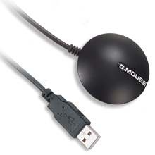
This was my very first GPS experience. The GPS BU-353 includes the receiver,
drivers, cables, and CDs with ROUTE 66 US and Canada Street Network 2004. It
was easy to install drivers and maps. And once I plugged the GPS receiver
into my computer I was off and running. My computer served as the navigation
screen.
I tested it going from Pennsylvania to Princeton, New Jersey, which is an
hour's ride. The GPS was accurate. tracking the entire route. I knew the
exact longitude, latitude, and altitude of my location at all times—and even
the speed the car was traveling. I was not driving. I was the passenger with
my PowerBook G4 connected to the GPS receiver receiving signals from several
satellites. Two satellites is the minimum for tracking a 2D position
(latitude and longitude). With three or more satellites there can be 3D
positioning (longitude, latitude and altitude).
It was very cool to see a moving arrow on the map on my computer screen
tracking the car's location as we drove.
The BU-353 is a self-contained waterproof, Mac-friendly GPS to help you find
your way anywhere in the United States and Canada. It has the SIRFIII high
performance GPS for the highest accuracy and WAAS(Wide Area Augmentation
System) capability, which improves accuracy to less than three meters on
average.
The receiver is waterproof and suited for multiple uses such as marine,
aviation, fire trucks, police cars, buses, utility and long haul vehicles.
The good news about GPS units is that they are getting inexpensive and have
better technology for better accuracy. The bad news is that I am working
with maps from 2004 for this review. Roads and buildings are constantly
changing and a more up to date map would have been better.
This is a very Mac-friendly device. There are many other GPS devices
developed by USGlobalSAT; some models are handheld with speech availability.
Their discounts for Macintosh User Group members are commendable and a
testament to their commitment to the Mac community.
They are currently working on making it compatible with the
MacBook Pro.
 |
Reviewer:
Maria O. Arguello
Maria is president and vendor liaison of the Main Line
Macintosh Users Group (MLMUG). She is the Apple User Group Regional Liaison
for the Northeast United States, as well as the Liaison for online groups.
|
This site has many more reviews, all written by MLMUG members.
View all our book reviews. Or, view
our
Software, hardware, and game reviews.
[ home
| newsletter | past
| join | listserve
| shareware | directory
| links | md9 ]
© 2006 by
Maria O. Arguello & MLMUG
Posted 03/21/06
Updated 04/05/06 (8PM)
|